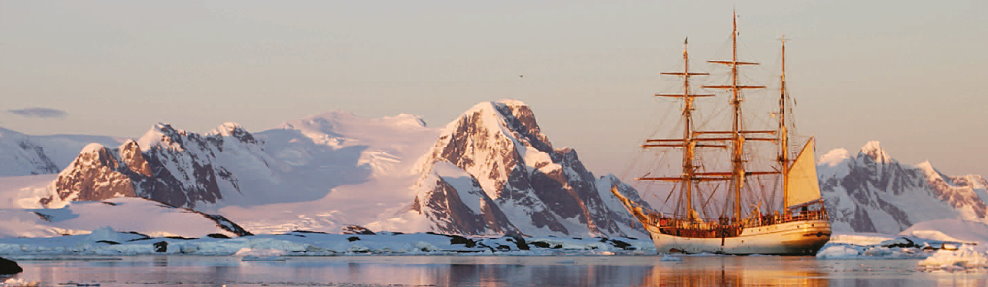
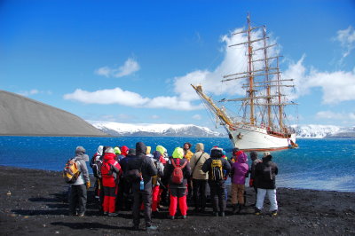
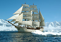
Antarctic Peninsula with the Barch Europa
Day 1 Punta Arenas
You are welcome on board at five p.m. The EUROPA is moored at the pier in Punta Arenas.
It is highly recommended that you arrive in Punta Arenas one day before embarkation, leaving room
for fl ight delays or late arrival of your luggage. Having additional time will also allow for hikes in
the Magallanes National Reserve, the historical site Bulnes Fort-Famine Port (place of the first
attempt for the European colonization of the area on 1843).
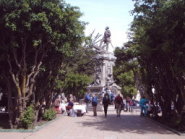
Another half day trip from the city can lead you to a Magellanic penguin rookery at Otway Sound. Other options include a walk around the city enjoying the waterfront along the Magellan Straits, the Plaza de Armas or the Punta Arenas Cementery.
After signing on to the crew list and taking your luggage to your cabin, you will enjoy your first meal on board. The
captain and the expedition leader will inform you about the plans. Departure is planned for the same evening.
You are welcome on board at five p.m. The EUROPA is moored at the pier in Punta Arenas.
It is highly recommended that you arrive in Punta Arenas one day before embarkation, leaving room
for fl ight delays or late arrival of your luggage. Having additional time will also allow for hikes in
the Magallanes National Reserve, the historical site Bulnes Fort-Famine Port (place of the first
attempt for the European colonization of the area on 1843).
Another half day trip from the city can lead you to a Magellanic penguin rookery at Otway Sound. Other options include a walk around the city enjoying the waterfront along the Magellan Straits, the Plaza de Armas or the Punta Arenas Cementery.
After signing on to the crew list and taking your luggage to your cabin, you will enjoy your first meal on board. The
captain and the expedition leader will inform you about the plans. Departure is planned for the same evening.
 |
Days 2 Chilean Fjords
Once underway, the crew will guide you through the ship’s safety procedures and help you to find your way through the hundreds of lines that are part of a square rigger. On our way to the White Continent we will first sail a south-westerly course through the Straits of Magellan, between steep green mountains and glacial fronts. In this area, the wind shifts make it a demanding sail and probably we will be predominantly motoring.
If possible, we will stop and enjoy a shore visit. During this first portion of the trip, we will be joined by two local Pilots who, together with our guide and Captain, will make sure that we are getting the most out of this voyage through the outskirts of South America along the island group of Tierra del Fuego (Land of Fire) and the Cape Horn Archipelago. They will stay with us until we leave the Beagle Canal and start the Drake Passage crossing.
 |
Days 3 – 4 Chilean Patagonia
Sailing in the southernmost Chilean Patagonia is the ideal way to view the wildlife on shore, in the water and sky. Just enjoy the beautiful landscape of the Cape Horn Biosphere Reserve. If possible, our progress will be under sail staying close to the southern shores and the Chilean side of the Channel, where we will pass Navarino Island and the Southernmost town of the world, Puerto Williams.
Our route will also take us past Ushuaia and the Argentine side, but these we will visit upon our return from Antarctica. Afterwards, we leave the Beagle Channel and head southwards. Wind, swell and weather depending, there is the possibility to attempt visiting the mythical Cape Horn, enjoying its rough environment and its famous lighthouse and albatross monument, before getting ready to sail south towards Antarctica though the Drake Passage.
Days 5 – 6 Drake Passage
The crossing of the Drake Passage is approximately 450NM from the lighthouse on Cape Horn. The seas around Cape Horn have the reputation to be stormy but in between the lows they are calm. The wind varies from southwest to northwest; it should, therefore, be possible to have a good crossing under sail. Cape petrels, White-chinned petrels and Albatrosses are our companions. Albatrosses are well equipped for a permanent stay at sea. Their territory is the open ocean. During the crossing
everybody can help the crew to steer, set, shorten, take away and stow sails
 |
 |
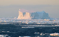 |
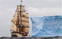
Day 7 Icebergs in Antarctic Waters
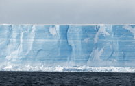
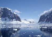
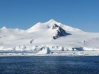
As we sail south, the likelihood of seeing icebergs increases. Large ice plateaus are visible on the radar, but sometimes smaller ones are not; we keep a good lookout so that we avoid them. Fortunately, the nights are short in the latitudes of 59° to 61° south. It is amazing when we see the brilliant white shapes of the floating icebergs on the horizon. They are huge, and very high! This is the first sign that we are really approaching the great white mass of Antarctica! We hope that we can drop our anchor in the evening in the sheltered bay of the Barrientos Island.
 |
Day 8 Anchoring near Barrientos Island, one of the Aitcho Islands
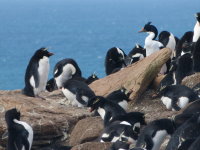
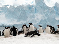
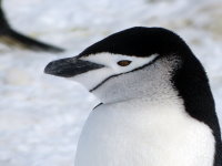
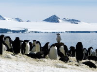
Everywhere around the ship we see penguins jumping out of the water. The crew will take us ashore with the dinghies. We share the beach with Gentoo and Chinstrap penguins. They walk with us up to the other side of the mountain where we find many Elephant seals. The Aitcho Islands are not completely covered by the ice cap. In the colourful patches of moss, Giant petrels and Antarctic skuas make their nests.
Day 9 Yankee Harbour or Hannah Point
We leave at dawn. For the first time on this voyage we will see the white ice cliffs around us. The chance of spotting a Humpback whale increases. Everywhere around us penguins give a show on floating ice. If there is enough time, we will sail to Edinburgh Hill, a rock that rises straight out of the water. Close up, we can see that it is made of basalt, solidified magma from the centre of a volcano. Pressure from inside the earth pushed the plug to this height, but so far the volcano has not erupted. When we sail into Yankee Harbour it looks as if we are sailing in between two handmade piers. They are, however, the work of Mother Nature herself.
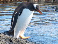
A rookery of Gentoo penguins crowds the beach. Occasionally we see a Weddell seal or a Fur seal. Hannah Point is a peninsula on the southeast coast of Livingston Island and is a veritable kingdom of animal life.Bird watchers can find nests of American sheathbills, Giant petrels, Skuas, etc. We also look for the Macaroni penguin; we might have the opportunity to meet a lost one. For today the final destination depends on various circumstances.
Day 10 Deception Island
Further south, on latitude 63° south, looms Deception Island, a ring-shaped island with an extensive internal crater. The EUROPA will sail through a small opening called ‘Neptunes Bellows’ into the volcanic crater and will drop anchor in Whalers Bay, near the ruins of a whaling station. Latterly the buildings where used as a base for research work, but in 1969/70 several stations were destroyed by a volcanic eruption. There is still volcanic activity in this area. You can walk to ‘Neptune’s Window’ and enjoy the magnificent view where the rim of the crater steeply goes back to the sea. It’s also an impressive panorama to look back into the crater.
A couple of miles further into the crater we sail to Pendulum Cove where thermal currents rise. Depending on the tide, those who so wish may bathe in geothermal warmed waters.
We leave at dawn. For the first time on this voyage we will see the white ice cliffs around us. The chance of spotting a Humpback whale increases. Everywhere around us penguins give a show on floating ice. If there is enough time, we will sail to Edinburgh Hill, a rock that rises straight out of the water. Close up, we can see that it is made of basalt, solidified magma from the centre of a volcano. Pressure from inside the earth pushed the plug to this height, but so far the volcano has not erupted. When we sail into Yankee Harbour it looks as if we are sailing in between two handmade piers. They are, however, the work of Mother Nature herself.
A rookery of Gentoo penguins crowds the beach. Occasionally we see a Weddell seal or a Fur seal. Hannah Point is a peninsula on the southeast coast of Livingston Island and is a veritable kingdom of animal life.Bird watchers can find nests of American sheathbills, Giant petrels, Skuas, etc. We also look for the Macaroni penguin; we might have the opportunity to meet a lost one. For today the final destination depends on various circumstances.
Day 10 Deception Island
Further south, on latitude 63° south, looms Deception Island, a ring-shaped island with an extensive internal crater. The EUROPA will sail through a small opening called ‘Neptunes Bellows’ into the volcanic crater and will drop anchor in Whalers Bay, near the ruins of a whaling station. Latterly the buildings where used as a base for research work, but in 1969/70 several stations were destroyed by a volcanic eruption. There is still volcanic activity in this area. You can walk to ‘Neptune’s Window’ and enjoy the magnificent view where the rim of the crater steeply goes back to the sea. It’s also an impressive panorama to look back into the crater.
A couple of miles further into the crater we sail to Pendulum Cove where thermal currents rise. Depending on the tide, those who so wish may bathe in geothermal warmed waters.
 |
Day 11 Trinity Island
We leave Deception’s crater and set course south, leaving the South Shetland Islands astern.
We drop anchor between Spert Island and Trinity Island and visit the beautiful ice scenery of small and large icebergs. Our trip in the dinghies takes us through a landscape of ice that is truly out of this world. The colours and shapes are stunning: overhangs with crystal clear icicles, ice-palaces that could have been created by Gaudí, massive gateways and open-air ballrooms. In some spots a piercing blue light shines through the ice and the water looks turquoise.
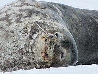
It is an impressive world created by extreme changes of temperature, sculpted by water and wind. Sometimes we are lucky and will see a Leopard seal.
Day 12 Gouvernøren Harbour (Enterprise Island) or Cuverville Island
Around this peninsula, whales search for krill in sheltered bays. The sight of whales feeding on krill is truly spectacular. On a previous expedition we saw the world’s largest animal here, the blue whale, which can reach more than 30m.
We will visit Enterprise Island, Gouvernøren Harbour. The bay is named after the whaler, the “Gouvernøren”, which was wrecked here in 1916. The 25m bow of the ship still rises out of the water. Breeding Antarctic terns now use the wreck. Cuverville Island is special because of the red and green mosses and is the home to skuas, Dominican gulls with chicks and some 4,800 pairs of gentoo penguins.
We leave Deception’s crater and set course south, leaving the South Shetland Islands astern.
We drop anchor between Spert Island and Trinity Island and visit the beautiful ice scenery of small and large icebergs. Our trip in the dinghies takes us through a landscape of ice that is truly out of this world. The colours and shapes are stunning: overhangs with crystal clear icicles, ice-palaces that could have been created by Gaudí, massive gateways and open-air ballrooms. In some spots a piercing blue light shines through the ice and the water looks turquoise.
It is an impressive world created by extreme changes of temperature, sculpted by water and wind. Sometimes we are lucky and will see a Leopard seal.
Day 12 Gouvernøren Harbour (Enterprise Island) or Cuverville Island
Around this peninsula, whales search for krill in sheltered bays. The sight of whales feeding on krill is truly spectacular. On a previous expedition we saw the world’s largest animal here, the blue whale, which can reach more than 30m.
We will visit Enterprise Island, Gouvernøren Harbour. The bay is named after the whaler, the “Gouvernøren”, which was wrecked here in 1916. The 25m bow of the ship still rises out of the water. Breeding Antarctic terns now use the wreck. Cuverville Island is special because of the red and green mosses and is the home to skuas, Dominican gulls with chicks and some 4,800 pairs of gentoo penguins.
Day 13 Continental landing at Paradise or Neko Harbour
The early birds heave anchor and we go further south to Paradise Harbour or Neko Harbour.
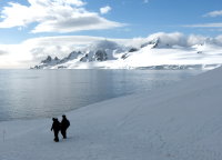
Here, huge, impressive glaciers of many shades of blue and white surround us. High cliffs of ice rise out of the sea. We hear the ice crack and see huge chunks of ice breaking off. Sometimes a wall of ice, tens of metres high, slowly tumbles down and when this huge mass large hits the seait sends a wave rolling under our ship. Being in the middle of this awe-inspiring natural wilderness is indescribable! Here we can visit the solid rock of the Antarctic continent.
The early birds heave anchor and we go further south to Paradise Harbour or Neko Harbour.
Here, huge, impressive glaciers of many shades of blue and white surround us. High cliffs of ice rise out of the sea. We hear the ice crack and see huge chunks of ice breaking off. Sometimes a wall of ice, tens of metres high, slowly tumbles down and when this huge mass large hits the seait sends a wave rolling under our ship. Being in the middle of this awe-inspiring natural wilderness is indescribable! Here we can visit the solid rock of the Antarctic continent.
Day 14 Argentine Islands
A long, popular day lies ahead of us. We head for “Kodak Crack”, the Lemaire Channel. 1,000m high mountains tower over the small channel. On ice shelves around us lie Crab-eater seals. Most people want to be on deck, filming or taking photographs of these beautiful sights. We enter Penola Strait. This stretch might be blocked by ice, and we will find it hard to force a way through, zigzagging round the icebergs and growlers.
The ice conditions might completely block our passage further south towards the Argentine Islands.
If the ice allows our passage, we will enter the archipelago towards the end of the day. We carefully thread our way between rocks and islets to our anchorage. We anchor at latitude 65° south, the southernmost point of our voyage. This evening we plan to visit the former British base ‘Faraday’, now a Ukrainian research station called ‘Vernadsky’. One of the research assistants gives us a tour round and tells us about their work. At anchor in bays like this, we have to keep a constant watch on the weather in case the wind direction changes. Pack ice can suddenly block our way out, preventing us from leaving.
Day 15 Petermann Island
We find a way out of the Argentine Islands, and anchor near Petermann Island a few hours later. For the first time we are near a breeding colony of Adelie penguins. The behaviour of these penguins, busy with feeding their hungry chicks, is different from that of the others we have seen. Neighbouring penguins wait until they see the feeding chick disappear half-way up the parent’s bill, then quickly steal small stones from the neighbour’s nest to build up and protect their own nest better. Skuas fly above the rookery and take every chance to snatch a penguin chick when the parents leave it unprotected. This island is a strong reminder of the French explorer Charcot, who spent the whole winter here on his ship the “Pourquoi Pas” (Why not) in 1909. The ship, a similar size to EUROPA, was moored in Port Circumcision (so named because the harbour was first discovered on January 1st 1909, the Catholic celebration of the circumcision of Christ To make sure that large icebergs couldn’t enter the bay during the winter and damage the ship, the crew stretched cables and chains across the mouth of the bay.
We find a way out of the Argentine Islands, and anchor near Petermann Island a few hours later. For the first time we are near a breeding colony of Adelie penguins. The behaviour of these penguins, busy with feeding their hungry chicks, is different from that of the others we have seen. Neighbouring penguins wait until they see the feeding chick disappear half-way up the parent’s bill, then quickly steal small stones from the neighbour’s nest to build up and protect their own nest better. Skuas fly above the rookery and take every chance to snatch a penguin chick when the parents leave it unprotected. This island is a strong reminder of the French explorer Charcot, who spent the whole winter here on his ship the “Pourquoi Pas” (Why not) in 1909. The ship, a similar size to EUROPA, was moored in Port Circumcision (so named because the harbour was first discovered on January 1st 1909, the Catholic celebration of the circumcision of Christ To make sure that large icebergs couldn’t enter the bay during the winter and damage the ship, the crew stretched cables and chains across the mouth of the bay.
 |
 |
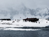
Day 16 Port Lockroy
Through Lemaire Channel and Peltier Channel, we reach the Bay of Port Lockroy. We watch blue-eyed shags ashore and in between the rocks, feeding their chicks. There has been a station here since 1944, and the area was declared a monument in the Antarctic Treaty of 1995. It is the oldest existing British station in Antarctica. During the Antarctic summers three British
people take care of this base. We will go ashore to visit the station. There we can buy postcards and stamps and send them from the most southerly post office in the world. Sometimes it will take a few months for a letter to arrive in Europe.
Ashore we see many Gentoo penguins. Leopard seals are often here, waiting for penguins to enter the water. For these speedy animals it is easy to catch one. Afterwards they lie around on the ice, digesting their last penguin feast.
Day 17 Dorian Bay
Close to Port Lockroy, on the other side of a beautiful icecap, we arrive in Dorian Bay. In the past, this icecap was used as a landing strip for small aeroplanes during the beginning of the summer season. We can’t cross it on foot; it might look like a beautiful, white plain of snow, but often there are deep crevasses spanned by snow bridges, some strong enough to carry a
man’s weight, some weak. Next to the ice cap we see Jabet Peak. The icecap stretches from high up near the mountain’s peak, reaching out into the sea, a massive, white tongue of snow. You will enjoy the magnificent view of the bay as
you walk around. You will see Gentoo penguins and occasionally a Weddell seal.
Late in the afternoon we leave and sail through the Schollaert Channel towards the Melchior Islands. On previous voyages we were sometimes lucky enough to see a pod of Killer whale’s come alongside to bid us farewell. Several large females with young came unbelievably close to the ship, distinguishable as female by the shape of their fin. They kept us company for so long that we had more than enough time to film them and take photographs of them against a beautiful backdrop
DAY 18 Melchior Islands
In the morning we make a last zodiac-tour before we depart from Antarctica. We bring along a chart and compass and navigate with the zodiacs in between the small islands and narrow passages, flanked by glaciers. We might see some Fur seals and Wilsons stormpetrels fly close to us.
Around noon, we leave sheltered waters and start the crossing back to South America. If the weather is clear we will still see Anvers Island after 100 miles, and Mount Francais, with her 3000-meter high summit, will remain in view for almost a day.
DAY 19, 20, 21 Drake Passage
Back in the watch system, we have time to absorb everything we have done, to let it all settle in. We will be accompanied on this passage by dolphins and many sea birds. Let us hope that the wind is favourable when we return towards Argentina. As we start our crossing from a more southern point, it takes us an extra day to sail the Drake Passage.
Back in the watch system, we have time to absorb everything we have done, to let it all settle in. We will be accompanied on this passage by dolphins and many sea birds. Let us hope that the wind is favourable when we return towards Argentina. As we start our crossing from a more southern point, it takes us an extra day to sail the Drake Passage.
DAY 22 Cape Horn and Tierra del Fuego
Soon we will see Diego Ramirez Island on our port side. Now we are near to the infamous Cape Horn. Cape Horn confirms to us that our crossing of Drake Passage is almost finished. Today we have reached quieter waters, sheltered by the rocks and islands of Tierra del Fuego. We set a course through the chaotic rocks and islands towards the Beagle Channel. The islands and fjords are remarkably green after our Antarctic visit. They are the habitat of more than 150 kinds of birds. Wild geese, beavers, rats and condors also inhabit this beautiful wilderness. On the Beagle Channel we wait for the obligatory pilot.
Soon we will see Diego Ramirez Island on our port side. Now we are near to the infamous Cape Horn. Cape Horn confirms to us that our crossing of Drake Passage is almost finished. Today we have reached quieter waters, sheltered by the rocks and islands of Tierra del Fuego. We set a course through the chaotic rocks and islands towards the Beagle Channel. The islands and fjords are remarkably green after our Antarctic visit. They are the habitat of more than 150 kinds of birds. Wild geese, beavers, rats and condors also inhabit this beautiful wilderness. On the Beagle Channel we wait for the obligatory pilot.
 |
DAY 23 Arriving in Ushuaia
We are close to Ushuaia, but there is still something to see on the way. A few miles before the port of Ushuaia we pass near two rocky islets covered with sea lions, the Islas de Lobos. So keep your binoculars at hand. Sea lions don’t go to Antarctica. Huge males lie around, keeping a watchful eye on their harem, protecting them from invaders. A little further on a Fur seal proudly grasps its prey, and blue-eyed shags take up every free metre of space. It’s packed. When we see the red and white lighthouse ‘Les Eclaireurs’, Ushuaia comes within sight and we enter the harbour. The citizens in Ushuaia look out over the Beagle Channel. From 1884 to 1947 Ushuaia was a safe haven for political exiles and criminals. The old prison is now open to the public. You are free to do as you please. A quiet walk or perhaps buy a few souvenirs in this welcoming town.
We are close to Ushuaia, but there is still something to see on the way. A few miles before the port of Ushuaia we pass near two rocky islets covered with sea lions, the Islas de Lobos. So keep your binoculars at hand. Sea lions don’t go to Antarctica. Huge males lie around, keeping a watchful eye on their harem, protecting them from invaders. A little further on a Fur seal proudly grasps its prey, and blue-eyed shags take up every free metre of space. It’s packed. When we see the red and white lighthouse ‘Les Eclaireurs’, Ushuaia comes within sight and we enter the harbour. The citizens in Ushuaia look out over the Beagle Channel. From 1884 to 1947 Ushuaia was a safe haven for political exiles and criminals. The old prison is now open to the public. You are free to do as you please. A quiet walk or perhaps buy a few souvenirs in this welcoming town.
DAY 24 Signing off in Ushuaia.
After breakfast you say goodbye to each other. Some will be able to stay for a few days In Argentina. For others the journey home has started. Antarctica has probably been an unforgettable experience for everybody. Some of you will have caught the Polar fever, which will never leave you.
After breakfast you say goodbye to each other. Some will be able to stay for a few days In Argentina. For others the journey home has started. Antarctica has probably been an unforgettable experience for everybody. Some of you will have caught the Polar fever, which will never leave you.
Please note: An itinerary to the Antarctic Peninsula was illustrated above. All itineraries are for guidance only. Programs may vary depending on local ice and weather conditions, the availability of landing sites and opportunities to see wildlife. The final itinerary will be determined by the Expedition Leader on board. Flexibility is paramount for expedition cruises. All offered activities, shore excursions and zodiac cruises are free of charge.